A Google Earth Engine App (prototype) to compare European countries NO2 Median changes during the Corona lockdown with the previous year.
A image gallery (ordered alphabetically, by users name) of almost all publicly available Google Earth Engine Apps.
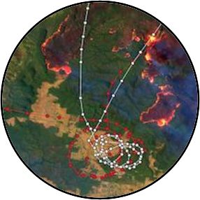
Every painting has its story. The same is true for satellite images. This blogpost is about a Sentinel-2 satellite image of the Australian bush fire and how a second data source helped to visualize fire-fighting missions.
A short tutorial on how to use Google Earth Engine inside RStudio with the GEE Python API and reticulate
- the R interface to Python.
Since April this year I tweet irregularly about Google Earth Engine management tips. This blogpost unites all tweets on this topic.
I wrote a little Earth Engine App where I compared the data availability of Sentinel-1C (Top of Atmosphere) and Sentinel-2A (Surface Reflectance) within the EE data catalog. This blogpost is about the code behind the App.
Since the 27th of March 2019 has the Earth Engine data catalogue one more dataset. Sentinel-2 Surface Reflectance (Level-2A) data are finally available. This blog post teaches you in one minute, how to get the current Sentinel-2 ingestion status for your country.