Every painting has its story. The same is true for satellite images. This blogpost is about a Sentinel-2 satellite image of the Australian bush fire and how a second data source helped to visualize fire-fighting missions.
Background
Australia had at the end of 2019 a unusually high level of bushfire activity and many hundreds of fire pictures were shown in the (social) media. But, one image (see Fig.2) was shown again and again. It is a image from ESA’s Sentinel-2 satellite, recorded on the last day of the decade, the 31th of December 2019 at 00:06:06 UTC (Coordinated Universal Time) equal to 11:06 AM, Sydney time.
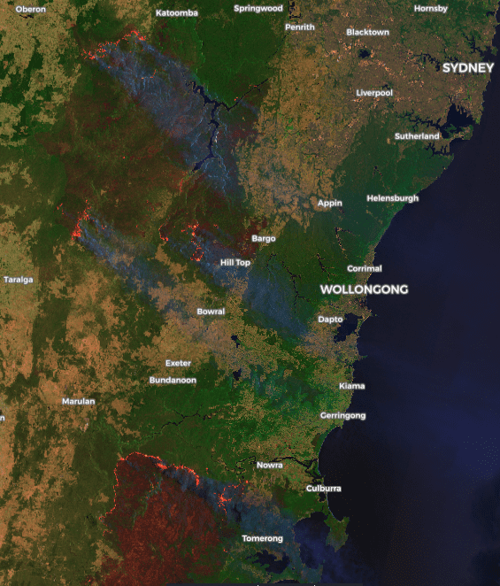 Fig.2 - Credit: European Union, contains modified Copernicus Sentinel data 2020, processed with EO browser
On New Year’s Day there were still many reports of people who had to flee and leave their homes and spent the night on the beach (eg. Mallacoota). But the big controversial topic of the day was actually the firework in Sydney and the ashes from the Australian fires that reached the glaciers in New Zealand. After that the media caravan moved on and other, more relevant, topics were covered elsewhere.
Look a little closer, stare a little longer
The Sentinel-2 image shows more than just fire and smoke. If we take a closer look we recognize the fire-fighting planes and helicopters which leave the airport or circle next to fires in order to drop their water bombs.
To simplify the search for fire-fighting planes I used flightradar24 playback. Playback (see Fig.3) allows to go back to Sentinel-2 recording time and identify the location of all planes in the image.
 Fig.3 - flightradar24 - Playback - 2019-12-31 00:06:06 UTC
Once identified, I downloaded the individual flight routes of the involved airplanes and helicopters and projected them on a Sentinel-2 false colour image which is based on band 8,4 and 3. If you wonder why there are three airplanes with funny colours visible, please check the explanation - Planespotting, by Tyler Erickson.
 Fig.4 - BMBR 138
 Fig.5 - BMBR 137
 Fig.6 - BMBR 911
BMBR 911
The background stories of some airplanes are interesting, for example the DC-10 Air Tanker 911 (BMBR 911, see Fig. 6) is leased from the United States to join the fleet of the NSW Rural Fire Service. Thankfully the DC-10 will be staying with the NSW RFS for the remainder of this Bush Fire Danger Period (BFDP). By the way, the water-bombing aircraft can drop 35,000 litres of water or fire retardant in eight seconds (ABC News).
We see the tanker (Fig. 6) at a altitude of 2.500 meter with a speed of 544 km/h going south. About 18 kilometres north-west of this place are the BMBR 137 and BMBR 138 in the process to suppress a fire close to Kanangra. Hopefully.
BMBR 137 & BMBR 138
To see the BMBR 137 (red point) and BMBR 138 (white point) airplanes position at the time of the Sentinel-2 recording, you must stop the video at 2019-12-31 00:06:06 UTC, or 00:42 sec of the video. Or you get your hand on the 3D version of the scene.
3D Model
Please, click into the map and move the mouse or cursor in order to zoom or pan.
Was the mission successful?
Whether the fires have spread considerably further or whether the fire-fighting mission was successful can be seen by comparing our Sentinel-2 image with a Landsat-8 image. The Landsat-8 image was recorded approximately 23:56 hours, or almost one day, after the Sentinel-2 image.
Helicopter mission
I found two helicopters fighting a fire near the Warragamba River. These are P2-CHY and N247AC. Both use the river as a water source and go there at regular time intervals.
 Fig.7 - P2-CHY - Jetphotos
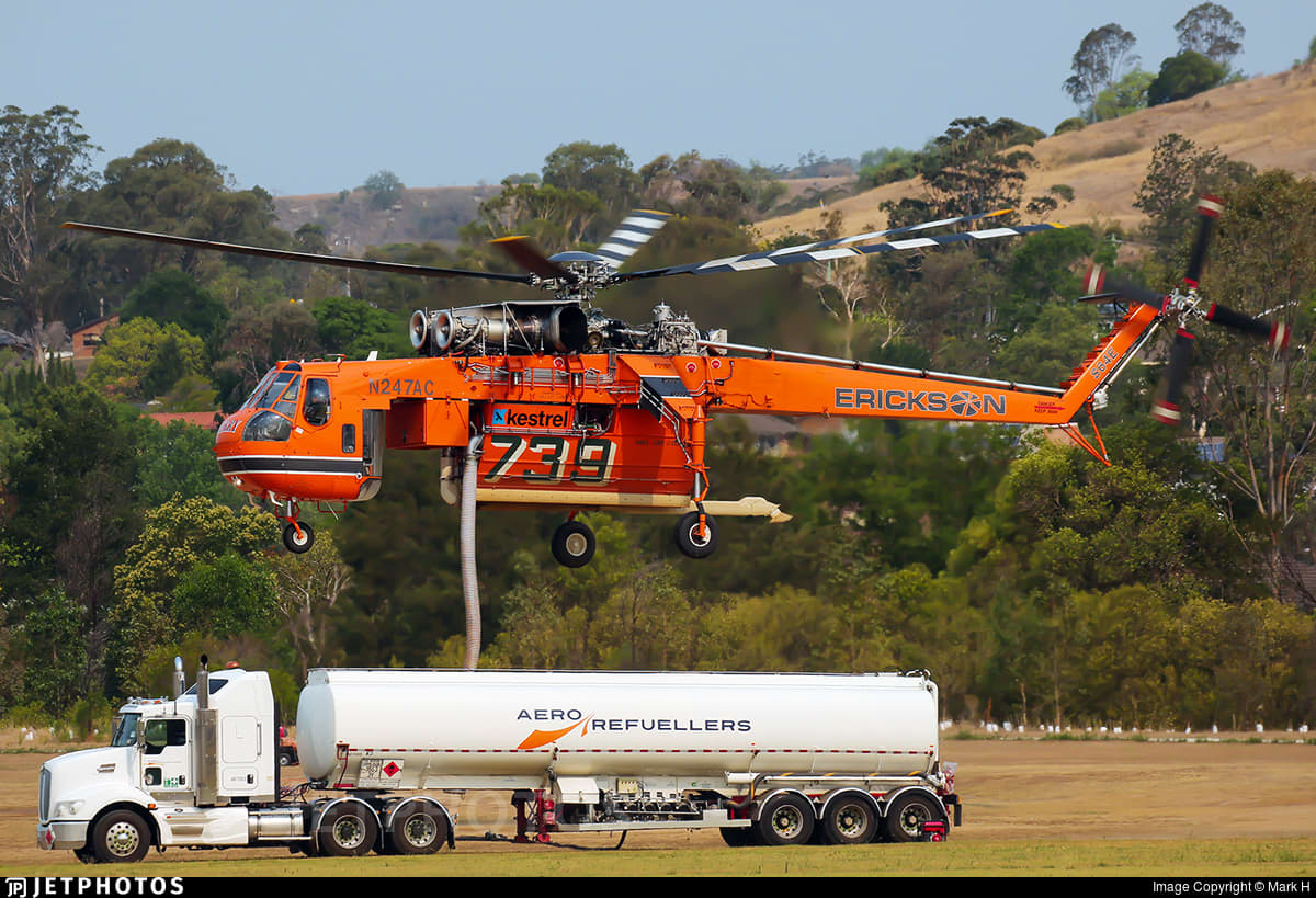 Fig.8 - N247AC - Jetphotos
Unfortunately the helicopters are not visible in the satellite image, but with the help of flightradar24 you can visualize their flight path.
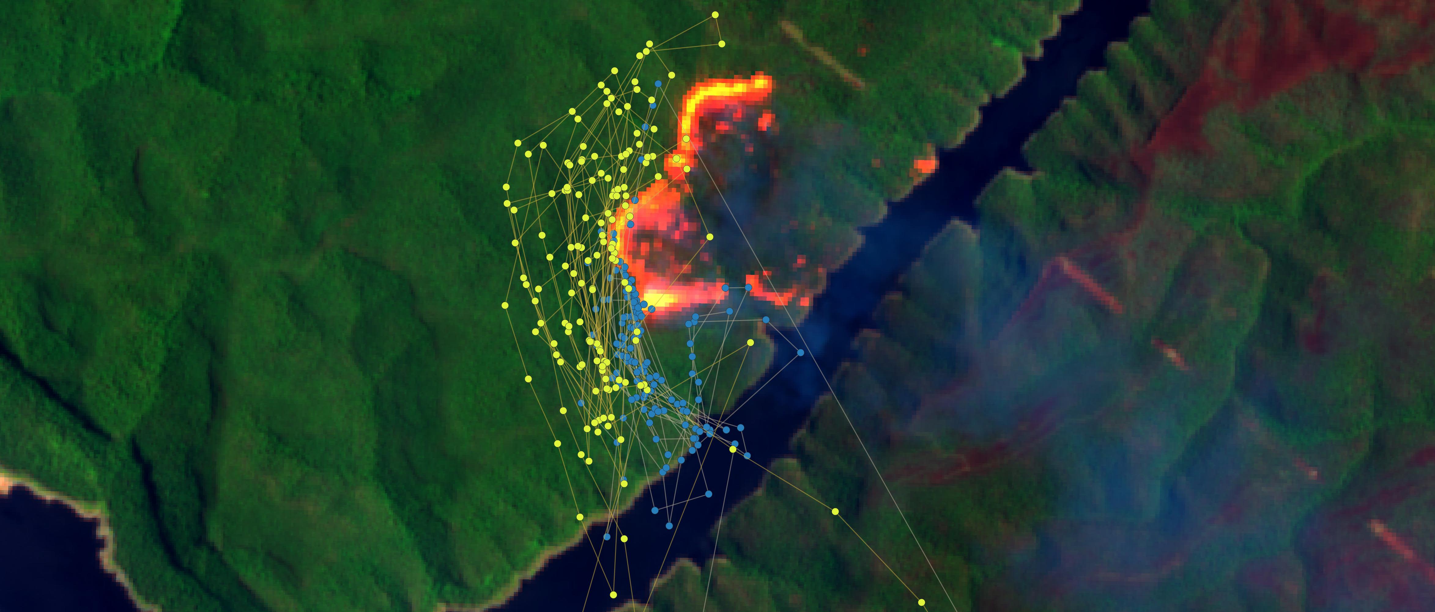 Fig.9 - Sentinel-2A from the 31.12.2019 00:06:06 UTC with flight paths of two helicopters the P2-CHY (blue points) and N247AC (yellow points).
From the ground, the operation must have looked like this.
Water bombing from 20 metres...#NSWfires #AustraliaBurning pic.twitter.com/WocTM8UQ19
— Dr Robbi Bishop-Taylor 🛰️🌎🌊 (@SatelliteSci) January 3, 2020
3D Model
Please, click into the map and move the mouse or cursor in order to zoom or pan.
One day later the fire has spread further
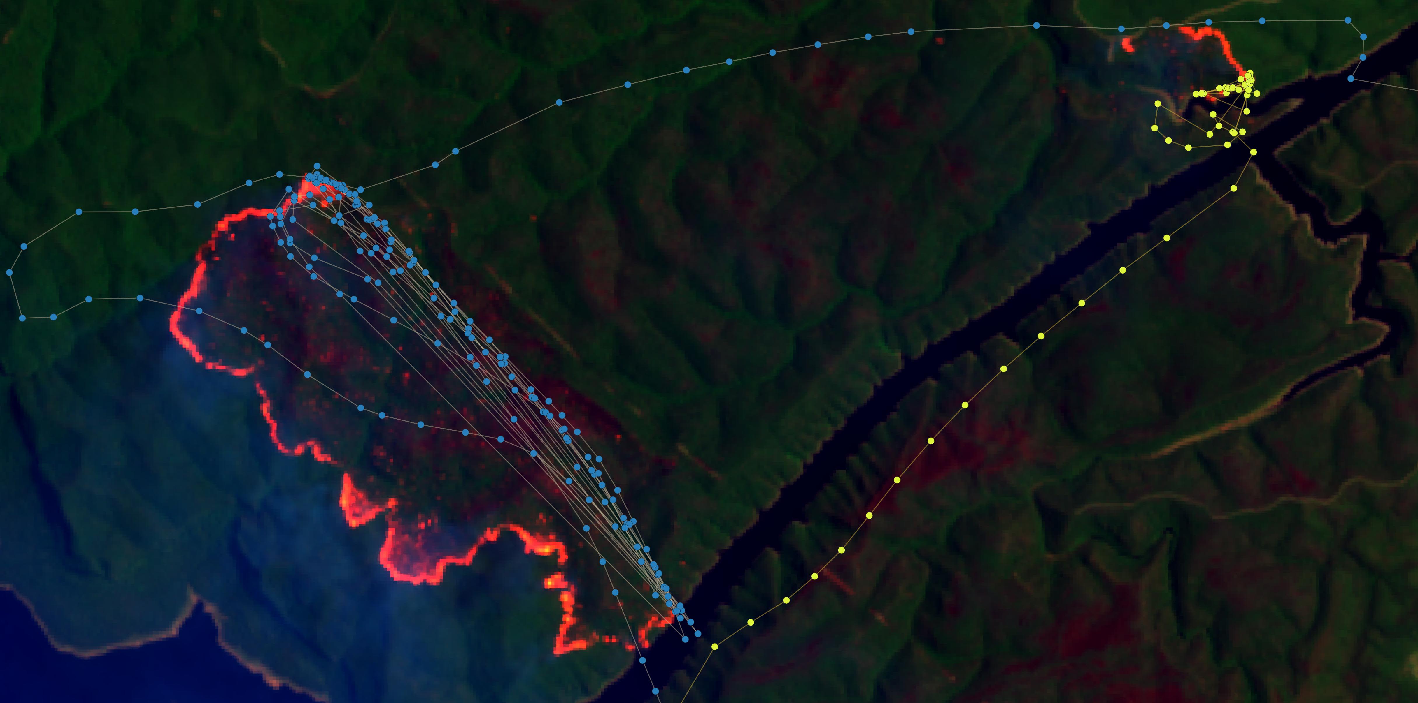 Fig.10 - Landsat-8 from the 31.12.2019 23:50:31 UTC with flight paths of two helicopters the P2-CHY (blue points) and N247AC (yellow points).
Sofware used
In this blog post, except for Fig.2, I mainly used the open source software - QGIS. The new Google Earth Engine plugin helped to visualize the Sentinel-2 and Landsat-8 data. I downloaded the flight routes from flightradar24, for this I used the GOLD subscription plan. The 3D models were made with Qgis2threejs plugin.
Bottom Line
You can cite this blogpost using: Gärtner, Philipp (2020/01/07) “Look a little closer - the story of a satellite image and fire fighting missions in Australia”, https://philippgaertner.github.io/2020/01/satelliteimages-airplanes-fire/
If you have any questions, suggestions or spotted a mistake, please use the comment function at the bottom of this page.
Previous blog posts are available within the blog archive. Feel free to connect or follow me on Twitter - @Mixed_Pixels.